My 2008 Appalachian Thru Hike Journal

Stories from five months of backpacking from Georgia to Maine

Summary

Georgia
Mar 1st to Mar 9th, 2008 Calculating... miles
Mar 9th, 2008
16 miles
Mar 8th, 2008
0 miles
Mar 7th, 2008
9.4 miles
Mar 6th, 2008
10.6 miles
Mar 5th, 2008
4 miles
Mar 4th, 2008
7 miles
Mar 3rd, 2008
13 miles
Mar 2nd, 2008
5 miles
Mar 1st, 2008
2 miles
Pre-trail
Sep 29th to Feb 29th, 2008 Calculating... miles
Feb 29th, 2008
miles
Jan 11th, 2008
miles
Nov 19th, 2007
miles
Oct 7th, 2007
miles
Oct 2nd, 2007
miles
Sep 29th, 2007
miles
North Carolina
Mar 10th to Mar 11th, 2008 Calculating... miles
Mar 11th, 2008
12.5 miles
Mar 10th, 2008
12 miles
Tennessee
Mar 31st to Mar 31st, 2008 Calculating... miles
Mar 31st, 2008
16.7 miles
Start: The Birches In Baxter State Park
Destination: Katahdin, Baxter Peak
Miles walked: 5.2
Total distance: Calculating...
Maine

Reaching for the summit

Start: The Birches In Baxter State Park
Destination: Katahdin, Baxter Peak
Miles walked: 5.2
Total distance: Calculating...
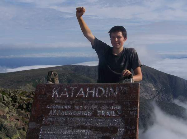
Reaching for the summit

There’s a spot on Mount Katahdin’s famed Table Lands called “Thoreau’s Spring”, named after Henry David Thoreau, who once roamed this plateau in his summit bid. The sign marking the spring it simply declares “Baxter Peak: 1 mile.” I turned to my hiking companion, Cookie, and said “One mile, that’s it? It’s over in one mile.”
        He simply responded “Yeah, it really is.”
        One mile to go. After walking 2,175.2 miles, there was only one to go. After traversing the Appalachian Mountains through 14 states by way of the Appalachian Trail, there was only one mile to go. After fighting through powerful winds, being chased by thunder and lightening on an exposed ridge, after walking through torrential down pours and unbearable heat, there was only one mile to go. After climbing to above 6,000 feet, and dropping to as low as 124 feet, there was only one mile to go.
It was time for me to complete the task, to walk that final mile. It was time for me to stand on that famed summit. The final mile was an emotional one. I was attempting to rationalize what it meant to me to actually see the summit, to know it’s no longer a distant goal but a visible objective. Then it hit me, there would be no tomorrow. Tomorrow I would not wake up and walk 20 miles. Tomorrow I would not wake up and complete the never ending array of town chores to prepare for the next stretch of trail. Tomorrow I would not wake up and wonder what America’s Footpath will throw my way next. Tomorrow it would really be over. Wait, it would really be over in less than a mile. A tear rolled down my face, containing my emotions was no longer necessary.
When I was a measly 1/10th of a mile from the summit, I finally saw the sign marking the end. I paused for a moment to regain my composure, and I glanced over at Cookie. He said to me in his southern accent, “There it is, Kirby.” I remained silent for a moment, and immediately broke down in tears.
        I turned to Cookie and said, “Yeah, there it is. Go on ahead, I’ll meet you at the end.”
        Seeing the sign was a powerful realization. I now realized that I would actually finish this trail, that I would go home victorious. I found it hard to believe I was actually standing where I was, considering everything it took for me to get that far.
        I slowly started to walk towards the summit, passing the final white blazes that have guided me this far. With each step, the sign became that much closer. With each step, I shed another tear.
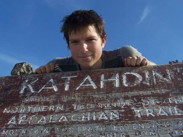
        And then there it was, the famous sign marking the most powerful summit on which I’ve ever stood. I stood there for a moment, gazing at the faded wooden sign that was emblazoned with the simplistic yet powerful words:

                                        Katahdin
                                       Baxter Peak-5,267
                          Northern Terminus Of The Appalachian Trail

It was actually over. There were no more mountains to climb by way of America’s Footpath, there were actually no more white blazes to follow. I finally stood on that famed summit.
I through-hiked the Appalachian Trail.

Ga>ME 2008

Start: Fire Warden's Cabin
Destination: Glencliff, NH: Hiker's Welcome Hostel
Miles walked: 20
Total distance: Calculating...
New Hampshire

Exposed in the White Mountains

Start: Fire Warden's Cabin
Destination: Glencliff, NH: Hiker's Welcome Hostel
Miles walked: 20
Total distance: Calculating...

Today was a 'go with the flow' type of day. I started out from Hawk Mountain around 6:45AM. I knew there was a storm coming, so I wanted to get to Gooch Mountain Shelter early and get a spot in the loft part of the shelter.

The high point of the day was lunch on the unmarked summit of Sassafras Mountain. There was a semi decent view, so I took a picture and ate some food. Beef jerkey is a great trail snack, and peanut butter on half a bagel fills me up quick right now, the hiker diet is not quite here yet.

I then moved on, going up and over some random bumps in northern Georgia, and descending into some interesting gaps.

The trail passes by some interesting creeks, and trees are starting to bloom in the lower elevation areas the trail passes through. Indeed, the trail is a green tunnel in some places, it makes for some nice hiking.

I then wandered my way to Justus creek, a nice water source along the trail. I then arrived at Gooch Mountain shelter around 10:45AM. I was planning on staying there for the night, but I decided it was too early to call it a day, so the General and I continued onto Woody Gap, mile 20.1 of the trail.

The trail from Gooch to Woody is not that difficult. There are nice views here and there, and steep climbs that made me stop and breath from time to time.

Woody Gap is a nice spot for a picnic. There is a gorgous view as you come off the trail, and there are high tech privies.

The Hiker Hostel picked me up around 2:30PM, and I was showered and doing laundry by 3:30PM.

I am not sitting in a comfy chair eating Chinese food and watching "Total Recall" staring Governor Schwarzenegger.

Tomorrow I will start late and go 7-9 miles, giving me a short day into Neel's Gap Wednesday. I was going to try to push to Neel's Gap tomorrow, but I decided I don't want to pay for two nights at Neel's, but that could change tomorrow, I will see how I feel.

Life on the trail is good.
Kirby

Ga>ME 2008.

Start: Spruce Peak Shelter
Destination: Peru Peak Shelter
Miles walked: 12.9
Total distance: Calculating...
Vermont

Ice Cream in Vermont

Start: Spruce Peak Shelter
Destination: Peru Peak Shelter
Miles walked: 12.9
Total distance: Calculating...

I awoke in semi-warmth at 5:45AM this morning. After completing the usual array of camp chores and waiting for Cookie to complete his, I was on trail at 6:50AM. The trail decided to cut up and down the side of a ridge for no logical reason, which seems to be a Green Mountain thing. Actually, that seems to be an Appalachian Trail thing. Eventually the trail did collide with Vermont 11/30. It took Cookie and me about 45 seconds to get a ride into town. The lady who gave us a ride works for the United States Forest Service, and she drove part her work to drop us right in the middle of town. Over the course of the morning and early afternoon I resupplied, replaced a pole tip, had some food at Bagel Works, and witnessed Cookie spend five dollars on a Ben and Jerry's milkshake he was clearly not enjoying. Apparently Ben and Jerry's is pretty big in Vermont. I think it's safe to say that the citizens of this fine state are a tad bit obsessed. At 1:20PM Cookie and I hitched out of town. This hitch took about 10 seconds. The locals around here are quite friendly. We were walking north at 1:35PM. Upon reaching the summit of Bromley Mountain we climbed the observation tower for a 360 view. It feels great to be back in the mountains and so close to home at the exact same time. We rolled into Peru Peak shelter around 6:00PM after traversing a ridge that was rich in the smell of pine. As always, I'm extremely heavy coming out of town. I'm of the opinion that it's better to roll into town with some extra food instead of finding yourself rationing your food closer to town. Onward tomorrow. Good night and good luck. Kirby

Ga>ME 2008

Start: Wilbur Clearing Lean-To
Destination: Congdon Shelter
Miles walked: 17.1
Total distance: Calculating...
Massachusetts

Storm Chasers

Start: Wilbur Clearing Lean-To
Destination: Congdon Shelter
Miles walked: 17.1
Total distance: Calculating...

I had town on my mind today, but I was not walking until 6:45AM. After completing a small climb out of the shelter, I was shot down to MA route two. At this road Cookie and I walked half a mile off trail to a Super Stop and Shop for resupply and some real tasting food. After consolidating food, eating donuts and relaxing around, we were walking north once more at 11:30AM. When we left town, it was unclear how much farther we intended to go. The climb out of the road was fairly gradual and not that difficult until just north of the Sherman Brook Campsite and the bad weather trail. In our path came a steep rock scramble leading to an underwhelming view. This is also where we met Greylock, the MA ridge runner. A little later I came upon the MA/VT border, which for NOBO's is marked by a sign declaring the start of the Long Trail. The LT and AT share the same corridor for 104 miles to Maine Junction, where the two venerable trails split. I was at the junction for the Seth Warner Shelter at 2:25PM. I deemed it was to early to stop and that I had not covered enough millage to justify stopping. Onward I went with Cookie leading the way. Then it began exploding. It first started with some distant rumblings of thunder. Then it began to lightly rain, which became heavy after a little while. Then came the pebble sized hail and powerful shocks of thunder and lightening. At this point Cookie and I were practically sprinting down the trail to get to the shelter as rapidly as possible. I rolled into the shelter at 5:00PM, physically exhausted. I had not hiked that fast in a very long while.Tomorrow I shall walk 18 miles. Steady feet don't fail me now. Good night, and good luck. Kirby

Ga>ME 2008

Start: Bald Mountain Shelter
Destination: Erwin, Tennessee/Uncle Johnny's
Miles walked: 16.7
Total distance: Calculating...
Tennessee

Bad sleep in Tennessee

Start: Bald Mountain Shelter
Destination: Erwin, Tennessee/Uncle Johnny's
Miles walked: 16.7
Total distance: Calculating...

"I slept pathetically horrible last night. I was rarely asleep for more than an hour at a time. So nauturally, I was up and moving once it was light out. One seems to have more motivation when town is what's waiting for you at the end of you r day. Today I had a rolling descent into Erwin, TN. There were many little ups and downs that eventually lead to a final dwescent into the outskirts of Erwin. I spent today thinking about many different things. I thought about how everything was on the homefront, and tried to figure out how I want to live my life when this thing comes to an end. I rolled into Erewin at 3:20PM, where I promptly checked into Uncle Johnny's Hostel, my home for the night. After checking in, I hung up my tent so it could air out and I did some laundry. I then gave my dad a call. He informed me that Sprint charges an arm and a leg for roaming calls. I spend a lot of time roaming because Sprint has a pathetic network down here. Verizon is the best network out here. Lesson learned. We hope to drop Sprint quickly and switch to Verizon. I then received a ride to a Mexican restaurant for dinner. I also completed my resupply. My next resupply will be Kincora, 70 trail miles north. I have not decided what I will do tomorrow, I have been too busy thinking about other things. My mind is a mess, right now. Good night, and good luck. Kirby

Ga>ME 2008"

Start: Muscrat Creek Shelter
Destination: Carter Gap Shelter
Miles walked: 12.5
Total distance: Calculating...
North Carolina

Dazed reality in North Carolina

Start: Muscrat Creek Shelter
Destination: Carter Gap Shelter
Miles walked: 12.5
Total distance: Calculating...

Woke up around 7:30AM, feelingh semi-shitty. Made breakfast, packed up, and moved out. I was on trail at 8:50AM. Standing Indian has switchbacks the whole way, so it was a fairly easy climb. I kept having to stop to take breaks today, I was not mentally wih it, I had no real urge to hike today, but that's all part of the game. I need to take the punches as they roll. Every now and then there were nice views, they are all the same now. I ate a lot of snacks today, it was my attempt to get my brain in the game. For the final part of the day I hiked with Hillbilly and Travis. Hillbilly is a funny man, and Travis is good company. Hillbilly and I are working on a trail name for him, we hope to have him one by Fontana Dam. I am now at a shelter for the night. There is a nice fire going. I am here with Hillbilly, Travis, Whitefish, and Wasabi. This journal entry has been difficuly to write, my brain is living in its own world today. Hope for the best, prepare for the worst. Kirby

Ga>ME 2008

Start: Dick's Creek Gap
Destination: Muscrat Creek Shelter
Miles walked: 12
Total distance: Calculating...
North Carolina

North Carolina Surge

Start: Dick's Creek Gap
Destination: Muscrat Creek Shelter
Miles walked: 12
Total distance: Calculating...

Crutch made us some pancakes, quite delicious. It was nice to trade trail stories with him, I picked his brain about the trail ahead. Today's hiking was mostly up hill, funny how you walk up hill to get to a gap. I was not really paying attention to the things around me, I was focused on getting to North Carolina. It felt odd to be standing on the GA-NC border. After nine days, including a zero, I was finally entering a new state. I took my picture at the border, and Hillbilly took my picture in front of the gnarled oak tree at Bly Gap. The climb out of the Gap was steep. Since I knew it was bad ahead of time, I set a nice slow pace and slowly but surely finished my final up hill sretch for the day. Muscrat Creek shelter is nice. I am officially in the hands of the Nantahala Hiking club. Goodbye GATC. I just watched the sunset on Raven's Cliff. Life is good. Kirby

Ga>ME 2008

Start: Unicoi Gap/Hiawassee
Destination: Dick's Creek Gap
Miles walked: 16
Total distance: Calculating...
Georgia

Where Are the Summits?

Start: Unicoi Gap/Hiawassee
Destination: Dick's Creek Gap
Miles walked: 16
Total distance: Calculating...

I arrived at Unicoi Gap at around 9:30-9:45AM. There was trail magic, I had a breakfast burrito courtesy of two former thru hikers. I put it in my pack and saved it for my lunch. It was delicious. Rocky Mountain has switchbacks to start, and then went straight up. This state is getting old fast. Tray mountain was a delight. Best views of the whole trip. It was windy up there, so I moved along. Then the trail went up and down over bumps, these were starting to take their toll on me. The trail went straight up, and then straight down. Rinse and repeat. That was my day. Thus far, these 16 miles were the toughest miles, both physically and mentally. Kelly's Knob was difficult. It went on and on. It has easily been the toughest climb of the trip. A few flase summits mixed in with a trail that goes straight up makes for a grueling climb. GATCL Please mark your summits. Thank you. At Dick's Creek Gap I took a break and ate some granola. I then began the three mile walk back to the Blueberry Patch. One mile away from the hostel, two day hikers offered to ride me the rest of the way. Trail magic number two. At the Blueberry Patch I packed my pack in preparation for the departure to Cloud9, the other hostel in Hiawassee. As I was waiting for the shuttle on the road in front of the Blueberry Patch, Mother nature and Smokestack drove past me. They ended up treating me to dinner, quite delicious. hank you very much Mother Nature and Smokestack. I enjoyed trading trail stories about the trail up to Dick's Creek Gap. I am now at Cloud9, enjoying a peaceful nght. All the other hikers are in town eating dinner. Apparently there is another 17 year old on the trail. I hope to track him/her down. There are very fiew of us out here, so I hope to connect with the ones I can. Kirby

Ga>ME 2008

Start: Unicoi Gap/Hiawassee
Destination: Unicoi Gap/Hiawassee
Miles walked: 0
Total distance: Calculating...
Georgia

Today, We Rest

Start: Unicoi Gap/Hiawassee
Destination: Unicoi Gap/Hiawassee
Miles walked: 0
Total distance: Calculating...

I left the Holiday Inn Express around 10:30AM for the Blueberry Patch Hostel. This hostel is perfect for rest, there is nothing to distract you. It is always calm, unusual for a hostel. A little later I played Rummy 500 with Hearts and Bill. I won with 580 points, second place was 410. August then asked me to help out on some yard work, which I gladly did. It helped lower the amount of money I have to leave. It is donations only, you pay what you can. After that we lounged around a bit. We then decided to go to Winton's birthday party at Neel's Gap. That was an idiotic move. I met some great people there, but there was way to much drinking for my taste. For the record, I do not drink. Not sure if I ever will. I am now back at the Patch, and I am exausted. Sorry this is short, I want to sleep. Kirby

Ga>ME 2008

Start: Low Gap Shelter
Destination: Unicoi Gap/Hiawassee
Miles walked: 9.4
Total distance: Calculating...
Georgia

Switchback Caravan

Start: Low Gap Shelter
Destination: Unicoi Gap/Hiawassee
Miles walked: 9.4
Total distance: Calculating...

I slowly but surely began the process of moving everything from my tent to the shelter. I then decided I was worthy of warm oatmeal and hot chocolate, so I fired up my stove and boiled some waer. I then, slowly, packed my backpack and talked to the other hikers. It is really quite fascinating to talk to other hikers, we all come from different backgrounds, and we all have fascinating stories. I hit trail around 8AM, my orginal plan was to stop at Blue Mountain Shelter for the night, 7.2 miles down the trail. The trail was wet and muddy. The trail was a river at times, I was assured all the water sources would be flowing. It was interesting walking in a cloud for most of the day, gives you a different take on your surroundings. The most interesting piece of wildlife I have seen on the trail has been some birds and varmint like species. I arrived at the shelter around 11AM, and attempted to dry things out. Mission failure. I then began the internal deabte of whether to stay or move on to Unicoi Gap. As the debate raged on internally, I realized there wasa homeless man at the shelter with me. He was a nice man. He neither begged nor took anything from us without consent, he only took things when offered. Also at the shelter were Bill and Jesse. We decided to move on to Unicoi Gap and to get a shuttle to the Cloud9 Hostel. The descent into the gap was slippery, due to the mud, the whole way. There were also stretches of rocks, it reminded me of hiking in Maine. Most of the descent has switchbacks, which is quite nice. The Maine Appalachian Trail Club should take note of these lovely things. About half an hour after I arrived in the Gap, August pulled in. We got to talking a bit, nice man. He hiked in 2005, and is at it again. He convinced me the hostel was not worth it, and that a Holiday Inn Express would in fact be cheaper when split four ways. August arranged a ride with a truck that was taking a rest break, we each agreed to give five dollars to the driver for the ride. August has mastered the art of Yogi-ing a ride from complete strangers. It turns out that since August;s father is a truck dirver, he could get us a discount on the hotel room. Instead of having to split 99 dollars four ways, it was only 70 dollars. August only charged me ten dollars for the room. I owe him one. I am going to consider this trail magic. I ended up saving five dollars compared to Cloud9, and I have access to a hot tub. I had chicken and spicy fries for dinner. I also bought enough food to get me to Franklin, NC, which is my next planned resupply. Tomorrow I shall take a zero mile day due to pending dangerous weather. There are tornado warnings all over the place, nothing for this region yet. Sunday I shall slackpack from Unicoi Gap to Dick's Creek Gap. My plan from Monday forward is vague, some tough decisions have to be made, and I might need tp move forward from my group, I shall seek my Dad's imput, that decision will be made in good judegement based on the situation at hand. Till then, time to prepare my pack for an 8:30AM departure to the Blueberry Patch Hostel. where I shall prepare to walk zero miles. Kirby

Ga>ME 2008

Start: Neel's Gap Hostel
Destination: Low Gap Shelter
Miles walked: 10.6
Total distance: Calculating...
Georgia

5am Pizza

Start: Neel's Gap Hostel
Destination: Low Gap Shelter
Miles walked: 10.6
Total distance: Calculating...

I woke up at 5AM hungry, so I reached over to my Domino's pizza box and ate my remaining two slices, quite delicious. I then woke up at 7AM. Pirate made pancakes and coffee for all the guests of the hostel. I ate four pancakes and drankl a cup of coffee, quite a tough life I am living. I then had a hot shower with soap, I have never had a greater shower in my life. I felt quite clean afterwards. I then threw everything in my backpack and walked 50 feet to the outfitter. A staff member helped me pack my backpack in a more effective way, it now carries a whole lot better. I hit trail around 10:30AM. There were a few climbs that made me curse the GATC. There were plenty of nice views today, my first day of hiking with a lot of views. I stopped a few times on an exposed rock and ate some pringles. I am at the point where I will pack a can of pringles out of a resupply, a great trail snack. Towards the end of the day there were many pointless ups and downs(PUDS), they eventually became mindless(MUDS). I am now at Low Gap Shelter, I had a lipton pasta packet for dinner. Adam(Por Boy) went from a nice man to a caulky and arrogant hiker. He has offended a lot of people wth his statements, including myself. I hope to have that be my only bad talk about another hiker in this journal. Shitty weather tomorrow, I am thinking I will only go 7 miles. Time for hot chocolate. Kirby

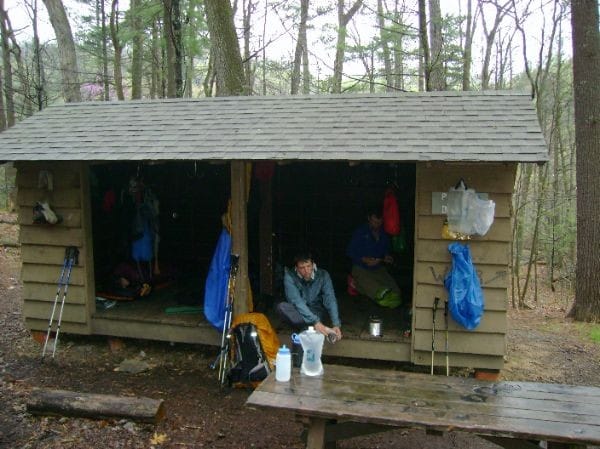
Start: Woods Hole Shelter
Destination: Neel's Gap Hostel
Miles walked: 4
Total distance: Calculating...
Georgia

Neel's Gap Shakedown

Start: Woods Hole Shelter
Destination: Neel's Gap Hostel
Miles walked: 4
Total distance: Calculating...

Today started out horrible. I woke up and it was cold and windy. My tent was sagging, and my gloves were useless, and I became cold quite rapidly. I quickly made the shelter picnic table my headquarters, and began the process of packing up as quickly as I could with nearly frozen hands, or so it seemed. I decided to move out quickly, so I just ate a granola bar and some cheaddar cheese crackers. I decided to take the Freeman trail around Blood Mountain because the weather was sketchy, and I was determied to get to Neel's Gap in short order. The Freeman trail has a lot of rocky stretches, reminds me of hiking in Maine. I covered those stretches was ease. The trail is fairly level, no significant climbs or descents. Apparently I missed the toughtest part of the AT descent into the Gap, I found the final 1.5 miloes to be enoyable. At Neel's Gap I had my pack shook down by Winton. I ended up buying a Jetboil, a sleeping bag liner, stove fuel, and some food resupply. Winton is a fantastic man. He helped me resolve a fiasco with my debit card. He answered every question I cound think of, and always has a smile on. When I started running low on cash on hand, je even offered to give me cash, as long as I paid him back once I hit Hiawassee. I declined, but it is the tought that counts from my perspective. Tomorrow morning Winton said he will help me pack my pack in a way that makes it carry better. Currently I am having friction problems along my waist, plaster tape has been quite useful in resolving that issue. Winton also said that he might be able to find a more effective way to set up my tent. I also learned my wool socks have built in sock linters, so I was able to send a pair home. I kept one just in case blisters develop. I have never had blisters on the back of my heels. Tonight I am staying at the hostel in Neel's Gap, overseem by Pirate. He is a nice man, strikes me as humble and quite friendly. Seems to be enjoying lige. I am currently watching Deliverance, waiting for my Domino's pizza to be delivered. I believe I will try for Low Gap Shelter tomorrow, not sure though. I will be in Hiawassee in three to four daus, a zero mile day might be in order. Kirby

Ga>ME 2008

Start: Woody Gap/AT Hiker Hostel
Destination: Woods Hole Shelter
Miles walked: 7
Total distance: Calculating...
Georgia

In the fetal position

Start: Woody Gap/AT Hiker Hostel
Destination: Woods Hole Shelter
Miles walked: 7
Total distance: Calculating...

When I woke up, today was very up in the air. There was a nasty storm moving through, so I was hesitant to leave in the morning. I ended up lounging around for most of the day. Weathe forcasts made it seem the storm would be gone by 2-3PM. I decided that I wanted a short day into Neel's Gap tomorrow, so I was determined to make it to Wood's Hole Shelter today. I hit trail around 2:15PM. On my descent of Big Cedar mountain I went into lightening position for about 20 minutes riding out a thin ban of severe weather I knew was coming. Once the weather passed, it started to cleap up. There were nice views here and there, so I toke some photos and moved on. I also got some photos of me in lightening position, and hiking in the rain. The trail was either flooded, muddy, eroded, or all of the above during todays hike, we thru-hikers cause a lot of damage to the trail, and I do here by take some of the responsibility for this. As I arrived at the full shelter, it became cold and windy fast. So I setup my tent as quickly as possible. I then cooked dinner in the shelter, it acted as a large windscreen. Tomorrow I shall go to Neel's Gap, four miloes away, not including the .4 I need to hike to get back to the trail. I think I am going to buy a new stove, and maybe even a tent if I can find one a like. Well, time to sleep, I want to get to Neel's Gap quickly tomorrow. It it now 7:59PM, one minute before hiker midnight. I am quite tired. Kirby

Ga>ME 2008

Start: Hawk Mountain Shelter
Destination: Woody Gap/AT Hiker Hostel
Miles walked: 13
Total distance: Calculating...
Georgia

Woody Gap Surge

Start: Hawk Mountain Shelter
Destination: Woody Gap/AT Hiker Hostel
Miles walked: 13
Total distance: Calculating...

The high point of the day was lunch on the unmarked summit of Sassafras Mountain. There was a semi decent view, so I took a picture and ate some food. Beef jerkey is a great trail snack, and peanut butter on half a bagel fills me up quick right now, the hiker diet is not quite here yet. I then moved on, going up and over some random bumps in northern Georgia, and descending into some interesting gaps. The trail passes by some interesting creeks, and trees are starting to bloom in the lower elevation areas the trail passes through. Indeed, the trail is a green tunnel in some places, it makes for some nice hiking. I then wandered my way to Justus creek, a nice water source along the trail. I then arrived at Gooch Mountain shelter around 10:45AM. I was planning on staying there for the night, but I decided it was too early to call it a day, so the General and I continued onto Woody Gap, mile 20.1 of the trail. The trail from Gooch to Woody is not that difficult. There are nice views here and there, and steep climbs that made me stop and breath from time to time. Woody Gap is a nice spot for a picnic. There is a gorgous view as you come off the trail, and there are high tech privies. The Hiker Hostel picked me up around 2:30PM, and I was showered and doing laundry by 3:30PM. I am not sitting in a comfy chair eating Chinese food and watching "Total Recall" staring Governor Schwarzenegger. Tomorrow I will start late and go 7-9 miles, giving me a short day into Neel's Gap Wednesday. I was going to try to push to Neel's Gap tomorrow, but I decided I don't want to pay for two nights at Neel's, but that could change tomorrow, I will see how I feel. Life on the trail is good.Kirby

Ga>ME 2008

Start: Stover Creek Shelter
Destination: Hawk Mountain Shelter
Miles walked: 5
Total distance: Calculating...
Georgia

Georgia stroll

Start: Stover Creek Shelter
Destination: Hawk Mountain Shelter
Miles walked: 5
Total distance: Calculating...

Today was an easy day, but quite enjoyable. To be quite honest, there was not really anything note worthy, there was a interesting open field about two miles south of the shelter, I believe it is used for logging, not sure though. The shelters are not nearly as crowded as people say, we are averaging 10-12 a night. There was also a large hollow tree along the trail, quite fascinating really. The trail is Georgia has been thus far. There are very few rocks and roots along the trail, makes for very nice hiking. I give props to the GATC for keeping this trail in order, thank you GATC! I was also able to send to my dad a couple text messages, which is good, I don't have a strong enough signal to call, but I can text with 1-2 bars of reception. Well, it is around 2PM. I am going to take a nap. Kirby

Ga>ME 2008

Start: Amicalola Falls Lodge
Destination: Stover Creek Shelter
Miles walked: 2
Total distance: Calculating...
Georgia

The game begins

Start: Amicalola Falls Lodge
Destination: Stover Creek Shelter
Miles walked: 2
Total distance: Calculating...
The game begins

The day started out well. I ate breakfast at the lodge, courtesy of Shiloh and Shadowmoss. They were great people and I thank them very much for breakfast. I also met Jan Liteshope, and Awol during breakfast. Jan gave me a container with beef jerkey, and Awol gave me a bookmark with the entire trail on it, thank you very much! I then went to a presentation by the GATC, quite enjoyable. I started the Approach Trail around 11AM. The Approach Trail is not that difficult, a couple steep climbs though. Springer is a tad bit more amazing when you walk 7.5 miles to get there. It was completely clear today, so I had a nice view to the west. It was odd being there after 18 months of thinking and planning. I am looking forward to my walk north. It will give me enough tome to sort out my post high school life. Tonight I am at Stover Creek Shelter with several other thrus. Life is good. Good night,Kirby PS:I met a nice man named John at Amicalola Falls. He hiked in 1976, real nice guy, nice family as well.

Ga>ME 2008

Total distance: Calculating...
Pre-trail

Prepare for Liftoff

Total distance: Calculating...

Here I am. Amicalola Falls State Park, roughly 2,183 miles from Katahdin. I am ready. Everything is set to go.

I feel surprisingly well considering. I am in the final stages of recovery from the cold, I get it every year.

It is currently 1PM, and I am laying in my tent at a campground here in the park. This campsite is quite nice. I have access to running water, bathrooms, and electricity. I had breakfast this morning at the lodge, it was quite delicious. And it was all you can eat buffet, only $8.00!!

Tomorrow morning I shall go to a presentation by the GATC. Then it is off to the Approach Trail to Springer, where I shall start my walk north.

Thanks everyone for the support, and I hope to see you on the trail somewhere,
Kirby

PS: It is now 8:18PM, 18 minutes past hiker midnight, and it is raining. This is good and bad. The good news is that the south is in a drought, so this will help the cause, The bad news is that rain is bad for the morale, but I am still having a blast. My group is fantastic. I can easily see myself hiking to Katahdin wth them/

Ga>ME 2008.

Total distance: Calculating...
Pre-trail

Close to Home

Total distance: Calculating...

By now, many of you have heard about the tragic events in regards to Meredith Emerson, I have no intention of restating any of the events regarding this story, as that is not fair to the family of the victim, accounts of what happened are widely available on the internet.

I am writing this entry mainly because some people in my life are concerned about me, and my safety. I am writing this to express to you how this has affected me, and its effects on my trip.

My hike is moving full steam ahead. What I learned from this story is to keep my guard up about suspicious people. I imagine other hikers I meet when I start will also be more cautious about personal safety. I have been asked by several people how I plan to change my willingness to tell people my timetable. No one knows my exact time table, except the group I am starting with. When I leave, there will only be a small group of people who will be kept up to date about my day to day plans, others will know where I am from time to time. This tragedy has affected me in ways that are hard to explain, it is a gut thing. This has sort of been a gut check, although it came in a horrible way. I'm sitting here, trying to figure out how best to sum this up from my point of view, but it is hard. Just know that I have recognized the tragedy, and that I will take proper action to ensure my personal safety.